Flights: 31
Days flying: 8
Images: 8000 (Vis, IR and RAW, 1 to 2cm resolution)
Operating Altitude: 2100 to 3500 ft
Environmental Temp: 5 deg to 43 deg
sUAV: QuestUAV 300 with Twin NDVI Cameras and QuestUAV 100 with Fwd Facing Camera
Output: Georectified Orthos, NDVI and FCC to 30cm Geospatial Accuracy
UAV Loss or Damage: none
Max range from Datum: 3km
Max alt from Datum: 1000ft
ABOUT THE PROJECT
Bulgaria has a rich archaeological history covering all the epochs. Pre history, middle and dark ages, Byzantine, Roman, Iron, Bronze and Neolithic. So when I was approached to participate in a “High Risk” exploration into one particular area of Bulgaria (Mirkovo) that was rich in this heritage, it seemed a fantastic opportunity to break new ground with the use of small UAV in archaeological research.
 |
| The Full Bulgarian Expedition Contingent |
LONG RANGE PREP
So it was a pretty cool project that took over a year to get to first flight, but had some fantastic results in terms of archaeological methodology, UAV Imagery, post processing and artifact collection. It is expected to lead to a number of research papers and a better understanding of the population dynamics of the area over the previous 8000 years. The project needed us to image a number of different subject types: arable land, pasture land and forest, both with known areas of archeology and with unknown areas (for prospection). Some areas also included the mountain range to the North of Mirkovo and a significant ridge to the West.
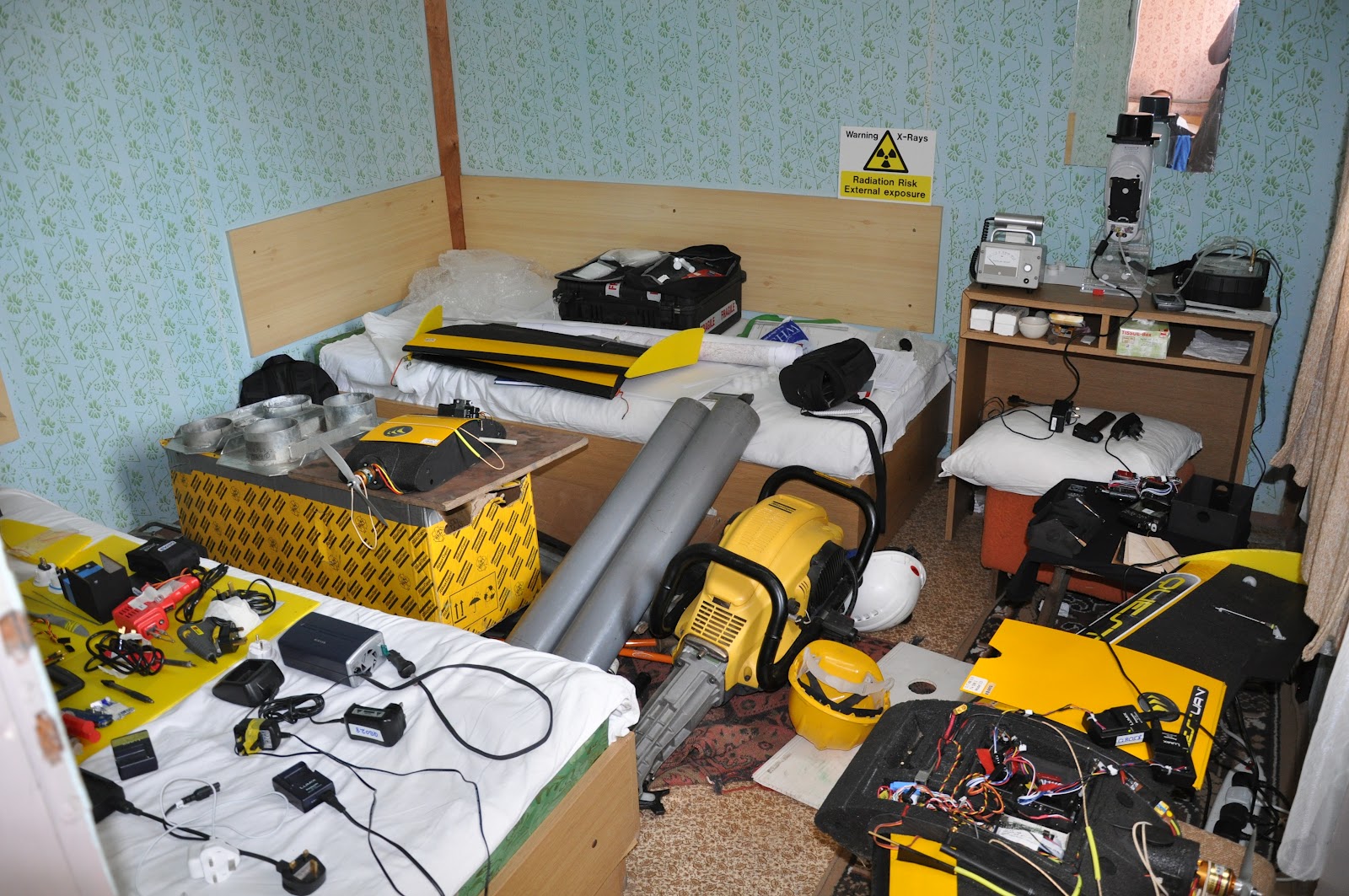 |
| One of our makeshift workshops |
Maps were an issue, both for planning and for the ground control laptops. Coverage and availability was pretty poor so we spent days compiling our own A1 and A2 sized maps and converting them into GIS. In the end we had excellent coverage both digitally and in paper form, but it was a lesson well learnt to be ready to work on this stuff months in advance.
TRAVEL OUT
The team that left from Northumberland comprised of myself (QuestUAV Director), Jon (Quest Systems Engineer), Dr Helen King (GIS and Post Processing) and Dr Jane Entwistle (Soils Specialist). When we arrived we took on board a new UAV team member, Sonya Tsekova, who stayed with us throughout our visit
Departure, transit and arrival was long, but went by without a hitch and all our kit arrived safely, despite now having in it a Radioactive Soils Analyser (XRF) courtesy of Jane. After an overnight in Sofia we travelled to the Mirkovo basin with our hosts, Jon and Bisserka, in the renowned JUPE (a 17 year old, well travelled 11 seater project transit van).
FLIGHT OPS

My concerns were about hot, high and heavy operations. The Mirkovo basin sits at around 2200ft with mountains rising to over 3000ft. Coupled with hot temperatures rising to the low forties and UAV’s carrying the full suite of cameras, these conditions were going to test the QuestUAV systems. We had the benefit of knowing that a QuestUAV 200 had operated completely successfully an Atacama desert operation at 10000ft, so at least we had a head start. I didn’t need to worry. The UAV’s performed impeccably throughout without ever seeming to labour or overheat. The standard 9x6 prop was used throughout.
Learning from Hannes’ experience in strong sunlight in the Alps, we took a half dome tent to provide shade for the UAV (and us at times!!). It was good call – in strong heat the wing tapes loose their adhesion and ten minutes in the sun was enough for this to start happening. Sometimes we had the shade from JUPE, the project van, to help us. Either way, finding shade was crucially important for UAV ops.

Mornings started cool and calm, giving us four hours of prep and flying time before heat and winds picked up. Then the next session would be after five in the afternoon where a couple of hours would afford us some nice golden, Bulgarian evening light. For archaeological reasons it was important to get low aspect sun conditions at times to show up such things as ridge and furrow.
What soon became apparent was that good landings were crucial. With so many flights yet to be done and typical landings being on hard, some times sunbaked dry ground with trees, old water pipes and other obstacles around, it became important to focus carefully on minimising landing risks. We had three aircraft but the aim was to damage none. We achieved it, but the discipline of carefully assessing the landing area, wind direction and approach run certainly improved this success. A bit of a wind would reduce the landing speed, but landing in a clearing would quickly kill that benefit in the relatively still wind inside the clearing. The QuestUAV are tough though and didnt mind being stopped by the occasional tree or bush or ploughed field. Even an occasional cartwheel didn't affect the airframe, the camera(s) or the gimbal.
PROCESSING
Day by day and flight by flight the results came in, first as bunches of images straight from camera, then as processed othrorectifications, then as georectified images. One task was to locate the "Tell" on our first of three sites. The tell was supposedly an ancient mound, first inhabited man thousands of years ago but probably built on a number of times since. It was known that it had long since been flattened as modern agriculture took place, but that traces should still exist in the signatures left behind in the earth and rock. We flew this site many, many times whilst a radiometric survey, coring and fieldwalking took place. Our flights comprised of visible, Infra Red , NDVI, oblique, early morning and late evening light, low, medium and high altitude. The ability of the UAVs to be launched so easily, often at different sites on one day, made the task of aerial data collection easy.
Each flight produced a three dimensional model that would be converted to an orthorectification using Agisofts very competent Photoscan Pro. Then as the ground control point data was added to the program a georectification would come out. As we raised the bar and became more technical with the QuestUAV 300, carrying it's twin NDVI cameras, overlapping orthorectifications from each camera would provide the information for the NDVI calculation, made using the raster calculator in ArcGIS. NDVI gave an option of false colour - an easier way for the untrained eye to see the subtle vegetation differences that marked underlying changes in soil structure. Evidence of completely different field structures, ridge and furrow, foundations, drainage, habitation and pathways started to come out.
The mosaics also allowed Digital Elevation Models (DEM) to be produced. This then allowed the subtle contours and level changes to mapped an a scale much more accurate than could be seen in even the most detailed maps. It appears that we found the Tell and the DEM helped define it, though it was never fully confirmed as so much change appears to have happened over recent history.
 With so much information to process it became a 24 hour process for the laptop we took out. Helen, our GIS expert, eventually became confined to her hut where the processing took place. We shared the nightime task of stacking up the ortho routines. Not everyone was successful and some night were a washout because the attempt to get the best accuracy sometimes was just too much for the laptop.
to be continued..
What soon became apparent was that good landings were crucial. With so many flights yet to be done and typical landings being on hard, some times sunbaked dry ground with trees, old water pipes and other obstacles around, it became important to focus carefully on minimising landing risks. We had three aircraft but the aim was to damage none. We achieved it, but the discipline of carefully assessing the landing area, wind direction and approach run certainly improved this success. A bit of a wind would reduce the landing speed, but landing in a clearing would quickly kill that benefit in the relatively still wind inside the clearing. The QuestUAV are tough though and didnt mind being stopped by the occasional tree or bush or ploughed field. Even an occasional cartwheel didn't affect the airframe, the camera(s) or the gimbal.
PROCESSING
Day by day and flight by flight the results came in, first as bunches of images straight from camera, then as processed othrorectifications, then as georectified images. One task was to locate the "Tell" on our first of three sites. The tell was supposedly an ancient mound, first inhabited man thousands of years ago but probably built on a number of times since. It was known that it had long since been flattened as modern agriculture took place, but that traces should still exist in the signatures left behind in the earth and rock. We flew this site many, many times whilst a radiometric survey, coring and fieldwalking took place. Our flights comprised of visible, Infra Red , NDVI, oblique, early morning and late evening light, low, medium and high altitude. The ability of the UAVs to be launched so easily, often at different sites on one day, made the task of aerial data collection easy.
Each flight produced a three dimensional model that would be converted to an orthorectification using Agisofts very competent Photoscan Pro. Then as the ground control point data was added to the program a georectification would come out. As we raised the bar and became more technical with the QuestUAV 300, carrying it's twin NDVI cameras, overlapping orthorectifications from each camera would provide the information for the NDVI calculation, made using the raster calculator in ArcGIS. NDVI gave an option of false colour - an easier way for the untrained eye to see the subtle vegetation differences that marked underlying changes in soil structure. Evidence of completely different field structures, ridge and furrow, foundations, drainage, habitation and pathways started to come out.
The mosaics also allowed Digital Elevation Models (DEM) to be produced. This then allowed the subtle contours and level changes to mapped an a scale much more accurate than could be seen in even the most detailed maps. It appears that we found the Tell and the DEM helped define it, though it was never fully confirmed as so much change appears to have happened over recent history.

to be continued..
I have visited your site all the sites are really good but if you really interested in technology then visit our site.
ReplyDeleteThe DJI ground station and also the place in tallying the instruction in that work has keep on disseminated will be to approximately gradation which uav flight controller development booked with the work of new peer collection user as a consequence which they be positioned unquestionably pleased as well as sworn just in what way it all may uprising as well as work wanting phantom 2 will motivation and the challenging in phantom 2 drone homes.